
iOS 開發中定位功能與地圖標注的實現示例
編輯:iOS 開發綜合
一、獲取位置與地理編碼
iOS 應用可以透過 Core Location 框架取得設備的地理位置。使用步驟是:添加 CoreLocation.framework 框架,導入 #import <CoreLocation/CoreLocation.h>。由於地圖與定位服務會消耗較多電量,一旦取到位置就應及時停止定位以節省電力。
核心在於實現 CLLocationManagerDelegate 的 didUpdateLocations: 方法,從中取得經緯度、精度、海拔與時間戳,並可進一步做「位置反編碼」(把座標翻譯成地址)。
- (void)createGPSMap {
    self.locationManage = [[CLLocationManager alloc] init];
    _locationManage.distanceFilter = kCLDistanceFilterNone; // 返回全部信息
    _locationManage.desiredAccuracy = kCLLocationAccuracyBest; // 最高精度
    _locationManage.delegate = self;
    [_locationManage startUpdatingLocation]; // 開始定位
}

- (void)locationManager:(CLLocationManager *)manager didUpdateLocations:(NSArray *)locations {
    CLLocation *newLocation = [locations lastObject];
    [_locationManage stopUpdatingLocation]; // 取到位置後立即停止定位

    // 經緯度
    CLLocationCoordinate2D coord2D = newLocation.coordinate;
    NSLog(@"緯度 = %f 經度 = %f", coord2D.latitude, coord2D.longitude);

    // 位置反編碼:把座標翻譯為地址信息
    CLGeocoder *geocoder = [[CLGeocoder alloc] init];
    [geocoder reverseGeocodeLocation:newLocation completionHandler:^(NSArray *placemarks, NSError *error) {
        for (CLPlacemark *place in placemarks) {
            NSLog(@"國家 = %@", place.country);
            NSLog(@"市 = %@", place.locality);
            NSLog(@"區 = %@", place.subLocality);
            NSLog(@"街道 = %@", place.thoroughfare);
        }
    }];
}
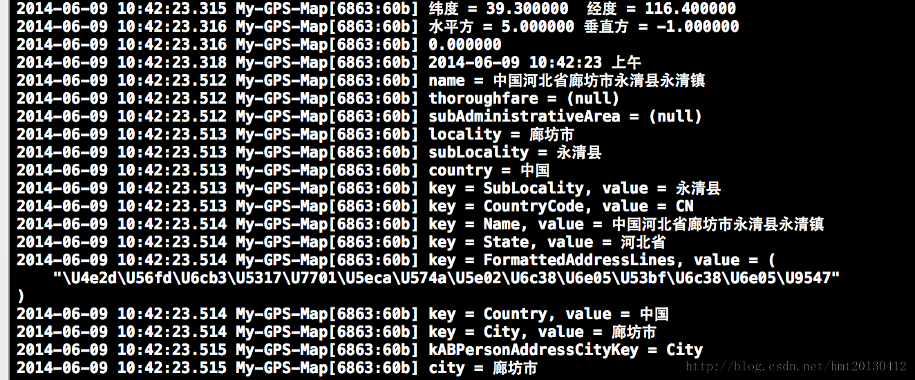
運行結果示例(以經度 116.4、緯度 39.3 為例):
反過來,若要根據「地址字符串」查詢座標(即「地理編碼」),使用 geocodeAddressString: 即可:
CLGeocoder *geocoder = [[CLGeocoder alloc] init];
[geocoder geocodeAddressString:_locationTextField.text completionHandler:^(NSArray *placemarks, NSError *error) {
    for (CLPlacemark *placemark in placemarks) {
        CLLocationCoordinate2D coordinate = placemark.location.coordinate;
        NSLog(@"緯度 = %3.5f 經度 = %3.5f", coordinate.latitude, coordinate.longitude);
    }
}];
二、地圖的使用與標注
取得位置後,可透過 MapKit 框架展示地圖。導入 #import <MapKit/MapKit.h>,並讓控制器遵循 MKMapViewDelegate 協議。以下為地圖初始化與自定義標注的核心代碼:
- (void)viewDidLoad {
    [super viewDidLoad];

    self.mapView = [[MKMapView alloc] initWithFrame:CGRectMake(0, 0, 320, 568)];
    self.mapView.showsUserLocation = YES;   // 顯示用戶當前位置
    self.mapView.delegate = self;
    self.mapView.mapType = MKMapTypeStandard; // 標準地圖(另有衛星、混合模式)

    // 經緯度、顯示範圍與區域
    CLLocationCoordinate2D coord2D = {39.910650, 116.47030};
    MKCoordinateSpan span = {0.1, 0.1};        // 數值越大,範圍越大
    MKCoordinateRegion region = {coord2D, span};
    [self.mapView setRegion:region animated:YES];

    // 添加自定義標注
    HMTAnnotation *annotation = [[HMTAnnotation alloc] initWithCGLocation:coord2D];
    annotation.title = @"自定義標注位置";
    annotation.subtitle = @"子標題";
    [self.mapView addAnnotation:annotation];

    [self.view addSubview:self.mapView];
}

// 返回標注視圖(大頭針視圖),類似自定義 UITableViewCell 的復用思路
- (MKAnnotationView *)mapView:(MKMapView *)mapView viewForAnnotation:(id<MKAnnotation>)annotation {
    static NSString *identifier = @"annotation";
    MKPinAnnotationView *annotationView =
        (MKPinAnnotationView *)[mapView dequeueReusableAnnotationViewWithIdentifier:identifier];
    if (annotationView == nil) {
        annotationView = [[MKPinAnnotationView alloc] initWithAnnotation:annotation reuseIdentifier:identifier];
    }
    if ([annotation isKindOfClass:[HMTAnnotation class]]) {
        annotationView.pinColor = MKPinAnnotationColorGreen; // 大頭針顏色
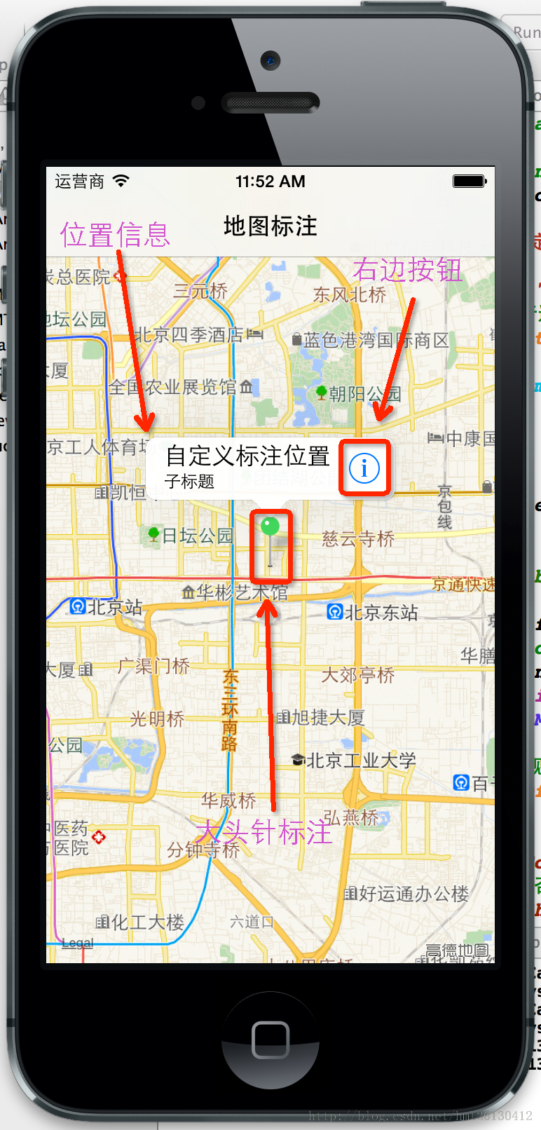
        annotationView.canShowCallout = YES;                 // 點擊是否顯示標題氣泡
        annotationView.animatesDrop = YES;                   // 從天而降的動畫
        // 標題氣泡右側的附屬按鈕
        UIButton *button = [UIButton buttonWithType:UIButtonTypeDetailDisclosure];
        [button addTarget:self action:@selector(didClickAnnotationViewRightButtonAction:) forControlEvents:UIControlEventTouchUpInside];
        annotationView.rightCalloutAccessoryView = button;
        annotationView.annotation = annotation;
        return annotationView;
    }
    // 當前設備位置的標注返回 nil,系統會創建默認標注視圖
    return nil;
}
自定義標注模型需遵循 MKAnnotation 協議,千萬別忘了引入:
#import <MapKit/MapKit.h>

@interface HMTAnnotation : NSObject <MKAnnotation>
@property (nonatomic, readonly) CLLocationCoordinate2D coordinate; // 座標
@property (nonatomic, copy) NSString *title;      // 位置名稱
@property (nonatomic, copy) NSString *subtitle;   // 子信息(可選)
- (id)initWithCGLocation:(CLLocationCoordinate2D)coordinate;
@end

@implementation HMTAnnotation
- (id)initWithCGLocation:(CLLocationCoordinate2D)coordinate {
    if (self = [super init]) {
        _coordinate = coordinate;
    }
    return self;
}
@end
此外,MKMapViewDelegate 還提供了 didUpdateUserLocation:(位置更新)、didSelectAnnotationView:(選中標注)、regionDidChangeAnimated:(地圖區域變化)等多個回調,可根據需求進一步擴展。若需要完全自定義錨點樣式,可考慮改用 MKAnnotationView(MKPinAnnotationView 只能以大頭針形式顯示)。
運行效果如下:
- 上一篇文章: 詳解 iOS 沙盒機制與文件操作
- 下一篇文章: 詳解 iOS 中 UIWindow 的使用與運行機制