
iOS 地圖開發詳解:MapKit 定位、標注與地址搜尋
編輯:iOS 開發綜合
本篇以 MapKit 為例,完整示範如何在 iOS 中實現地圖顯示、定位、標注與地址搜尋。以下依步驟說明。
一、準備工作
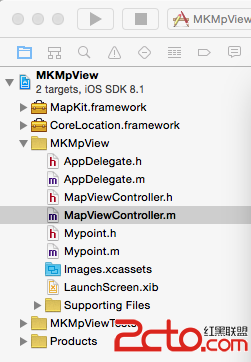
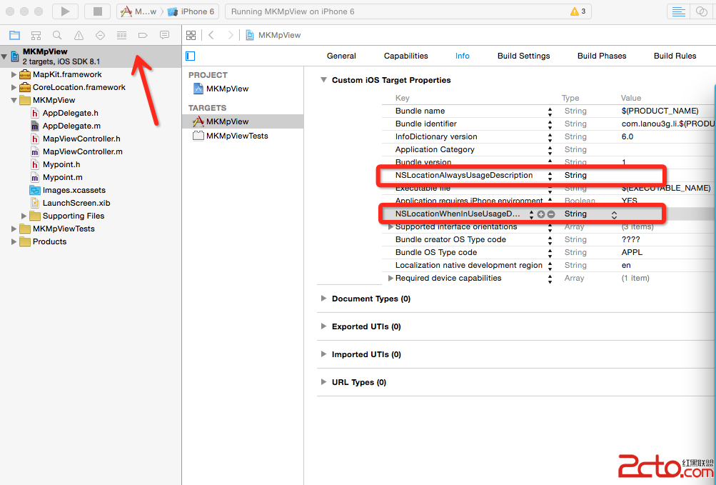
首先需要引入 MapKit 與 CoreLocation 相關類庫,並在 Info.plist 中加入定位用途說明字串:
需要添加的兩個字串為:NSLocationWhenInUseUsageDescription 與 NSLocationAlwaysUsageDescription。
二、設置根視圖與屬性
[[UINavigationBar appearance] setBarTintColor:
    [UIColor colorWithRed:23/255.0 green:180/255.0 blue:237/255.0 alpha:1]];
self.window.rootViewController = [MapViewController new];
在 MapViewController 中聲明所需屬性,包含 MKMapView、經緯度輸入框與標籤、標注按鈕、地址輸入框、查詢按鈕,以及 CLLocationManager 定位管理器。
三、初始化定位與視圖
- (void)viewDidLoad {
    [super viewDidLoad];
    self.view.backgroundColor = [UIColor whiteColor];
    self.locManager = [[CLLocationManager alloc] init];
    _locManager.delegate = self;
    _locManager.desiredAccuracy = kCLLocationAccuracyBest; // 定位精度
    _locManager.distanceFilter = 10.0;                     // 定位頻率:10 米一次
    [self.locManager requestAlwaysAuthorization];
    [self.locManager startUpdatingLocation];
    [self countDistance];       // 查詢兩地點間的距離
    [self configureView];       // 布置視圖
    [self setMapView];          // 建立地圖
}
布置視圖時,加入經度與緯度輸入框、放置標注按鈕、地址輸入框與查詢按鈕;並可透過 CLLocation 計算兩座標之間的距離:
- (void)countDistance {
    CLLocation *loc1 = [[CLLocation alloc] initWithLatitude:34 longitude:113];
    CLLocation *loc2 = [[CLLocation alloc] initWithLatitude:35 longitude:113];
    CLLocationDistance distance = [loc1 distanceFromLocation:loc2];
    NSLog(@"(%@) 和 (%@) 的距離為: %f", loc1, loc2, distance);
}
四、處理定位回呼
- (void)locationManager:(CLLocationManager *)manager didUpdateLocations:(NSArray *)locations {
    CLLocation *location = locations.lastObject;
    NSLog(@"經度 == %f, 維度 == %f", location.coordinate.longitude, location.coordinate.latitude);
    self.longitudetext.text = [NSString stringWithFormat:@"%f", location.coordinate.longitude];
    self.latitudeText.text = [NSString stringWithFormat:@"%f", location.coordinate.latitude];
    // 不用定位服務時應立即停止,因為非常耗電
    // [manager stopUpdatingLocation];
}
五、顯示地圖與放置標注
建立地圖視圖時可選擇標準、衛星或混合地圖類型,並透過 showsUserLocation 顯示當前位置:
- (void)setMapView {
    self.mapView = [[MKMapView alloc] initWithFrame:CGRectMake(0, 100, 320, 460)];
    [self.mapView setMapType:MKMapTypeStandard];
    self.mapView.showsUserLocation = YES;
    self.mapView.delegate = self;
    [self.view addSubview:self.mapView];
}
依輸入的經緯度放置標注並放大到該位置:
- (void)annotationAction:(UIButton *)sender {
    CLLocationCoordinate2D location = CLLocationCoordinate2DMake(
        [[self.latitudeText text] floatValue], [[self.longitudetext text] floatValue]);
    NSString *title = [NSString stringWithFormat:@"%f,%f", location.latitude, location.longitude];
    Mypoint *myPoint = [[Mypoint alloc] initWithCoordinate:location andTitle:title];
    [self.mapView addAnnotation:myPoint];
    MKCoordinateRegion region = MKCoordinateRegionMakeWithDistance(location, 0.01, 0.01);
    [self.mapView setRegion:region];
}
六、依地址搜尋位置
透過 CLGeocoder 進行地理編碼,將地址字串轉換為座標:
- (void)detailSearchAction:(UIButton *)search {
    if (_destination.text == nil || [_destination.text length] == 0) {
        return;
    }
    CLGeocoder *geocode = [[CLGeocoder alloc] init];
    [geocode geocodeAddressString:_destination.text completionHandler:^(NSArray *placemarks, NSError *error) {
        if (error || placemarks.count == 0) {
            NSLog(@"地址不存在");
        } else {
            CLPlacemark *firstPlacemark = [placemarks firstObject];
            CLLocationDegrees latitude = firstPlacemark.location.coordinate.latitude;
            CLLocationDegrees longitude = firstPlacemark.location.coordinate.longitude;
            self.latitudeText.text = [NSString stringWithFormat:@"%.2f", latitude];
            self.longitudetext.text = [NSString stringWithFormat:@"%.2f", longitude];
            [self showLocation];
        }
    }];
}
最後,自訂的標注類別 Mypoint 需遵循 MKAnnotation 協定,並實作 initWithCoordinate:andTitle: 初始化方法:
@interface Mypoint : NSObject <MKAnnotation>
@property (nonatomic, readonly) CLLocationCoordinate2D coordinate;
@property (nonatomic, copy) NSString *title;
- (id)initWithCoordinate:(CLLocationCoordinate2D)c andTitle:(NSString *)t;
@end

@implementation Mypoint
- (id)initWithCoordinate:(CLLocationCoordinate2D)c andTitle:(NSString *)t {
    if (self = [super init]) {
        _coordinate = c;
        _title = t;
    }
    return self;
}
@end
最終效果如下:
- 上一篇文章: iOS UI CodeSnippet:常用控件與布局程式碼片段整理
- 下一篇文章: iOS 自定義 cell 進階版:可展開的分組列表實作